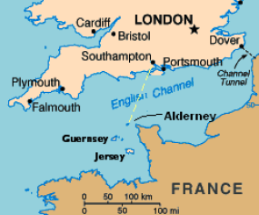
The first observation of a bright light was made by the pilot of a BN2a Mk3 Trislander (Aurigny Airline 544, G-XTOR) inbound to Alderney from Southampton on a heading of 207° on airway R41, at a position some 13nmi NNE of the ORTAC reporting point. ORTAC (approx. N 50°W 02°) marks the boundary on air route R41 between the London Flight Information Region (FIR) and the Brest FIR. It is also the N boundary of the Channel Islands Control Zone served by Jersey radar.
Capt. Raymond Anthony Bowyer began flying in 1984 and at the time of the sighting had been a professional airline pilot for 18 years, piloting numerous aircraft types (PA 34 Navajo, Fokker 27, Trislander and others) on routes in the Channel Islands, UK and Europe for companies including Novair, Regionair, Channel Express, Jersey European and Fan Air Europe. He had flown this particular aircraft, Trislander G-XTOR, on this Southampton-Alderney route for 8½ years, amounting to between 500 and 600 round trips s1Interview by Paul Fuller, Southampton Airport, 8 June 2007, text reviewed by Capt. Bowyer and corrected and updated 16 July 2007 (see Appendix B).
The aircraft was in cruise at 130 knots (IAS) at somewhat over 4000 ft n1The cruise altitude was FL40, or a standard pressure altitude of 4000ft. True altitude ASL differs from this depending on local air pressure, as explained in Section 3. It was a largely cloudy afternoon (see Section 5) with direct sunlight blocked by medium level altocumulus and high level cirrus (sun ~ 45 deg elevation in the SW, ~17° to the right of the flight path). The E and W horizons were cloud-obscured, and there was a layer of thin haze below the aircraft at approximately 2000ft. But the horizon ahead was free of cloud, and visibility was estimated 100 miles at the flight altitude. The islands of Alderney and Guernsey were also clearly visible.
The time was about 1406Z n2See Section 3 for a reconstruction of times and distances based on Jersey ATC radar plots. when Capt. Bowyer noticed a bright light close to the horizon almost directly ahead of the aircraft. His initial impression was that he could be seeing sunlight reflected from large vinery glasshouses on the Island of Guernsey tens of miles away. He had often seen such an effect before, which would vanish in moments as the aircraft moved through the critical angle for reflection. But this light did not disappear, and looking closer he realised that it was something unusual apparently in the sky at or near to his own altitude (we will refer to this object as UAP #1).

The flight controls were set to 'autopilot', leaving Capt Bowyer free to observe the UAP with the naked eye and with 10x magnification binoculars. He observed what appeared to be a "sparkling yellow" object (also described as "bright orange-yellow", "golden yellow" and "sunlight yellow") whose profile was like that of a thin cigar suspended horizontally above the horizon. It appeared to be self-luminous rather than reflective and was "brilliant" but not dazzling or tiring to the eye. It had "very sharply defined" edges and pointed ends. Approximately 2/3 of the way from the left hand end, like a narrow band around a cigar (about 1/10th of the length of the object), was a "dark graphite grey" patch. The edges of the band where it met the bright yellow were not sharp but"hazy" and the dark colour had a "shaky" or "glittering" quality that he found hard to describe, but which he felt was an objective property of the object and not an optical illusion (Figs. 2 & 3).
The naked eye angular subtense of UAP #1 when first seen was estimated later as equivalent to 6-7mm at arm's length, or approximately 0.5° of arc. His initial impression was that it was a 737- sized object, or bigger, at about 4000 ft altitude somewhere near ORTAC, not more than about 15nmi away.

At 14:09:32Z, after about 3 min observing with binoculars, the object was still ahead of the aircraft, just a few degrees to the right of the nose, and Capt Bowyer now radioed Jersey Control Zone on 125.2MHz. He asked the controller, Paul Kelly, "Do you have any traffic, can't really say how far, about my 12 o'clock, level?"
Kelly replied, "No, no known traffic at all in your 12 o'clock".
"Roger," replied Bowyer, "I've got a very bright object . . . extremely bright yellow, orange object, straight ahead, very flat platform, looking at it through binoculars as we speak."
Immediately Kelly responded that he did now have "a very faint primary contact", 11 o'clock at 4 miles from the aircraft. Bowyer acknowledged.
After half a minute Bowyer again asked Kelly, "any more information on that aircraft please?"
There was still a primary contact on the left of the Trislander, said Kelly, now 10 o'clock at a range of 3 miles, but nothing that appeared to correspond to the visual UAPs. Kelly thought the contacts might be false echoes caused by anomalous propagation.

At about 1412:30Z Capt Bowyer crossed the 50° parallel of latitude and passed left abeam the ORTAC reporting point. At about this time he noticed a second object (UAP #2) a little to the right of the first, and at slightly higher elevation, as shown in Fig.4. This one was identical in appearance including the golden yellow colour and asymmetrical graphite-grey band, except that #2 looked smaller, was a little less bright and seemed further away. Both objects were seen to the W of Alderney and to the right of the aircraft flight track, but to the left of the Casquets lighthouse n3 Casquets is a small islet at 49 43'42"N 02 22'42"W according to Trinity House records. Examination of the location on Google Earth discloses only a patch of darker sea colour that possibly indicates the rising underwater contours, i.e. the seamount of which Casquets is the exposed summit. The Casquets Light itself should not be confused with the sandbanks and reefs S of the lighthouse which are also known as the Casquets., which at this time was visible about 12° to the right of the flight line. They were both visible simultaneously in the same binocular field of view, laterally separated by only a degree or so s2The binocular FOV at 10x magnification is estimated to be approximately 6°. "As the flight continued," emphasised Capt Bowyer, "the second appeared above the first, whereupon finally the second appeared to the left of the first [UAP] at last sighting" s3Email to Martin Shough 09.06.07..
He reported the appearance of this second object to Jersey ATC at 1414:04, and observed that they both appeared to be somewhere west of Alderney. Seconds later at 1414:23 the Controller replied that a primary radar contact was now showing in the area of the Casquets. Capt Bowyer replied that this possibly corresponded with the position of UAP#2.

As the Trislander continued in flight towards Alderney three changes happened: The UAPs changed their bearings relative to one another; they changed their elevation relative to the horizon; and their angular sizes increased.
By approximately 1416Z, as the plane was about to begin its turn towards Alderney, the two UAPs had closed their lateral separation and appeared "lined up" one directly above the other. Also at this time the line of sight to the UAPs had fallen slightly below the horizontal, so that just before beginning the descent from FL40 Capt Bowyer estimated that they appeared at a shallow depression angle of about -2°, against the sea.
As the plane descended and turned to the left, further away from the line of sight, the elevation angle rose back towards the horizontal and UAP #2 continued its relative drift to the left of #1, i.e., reversing their original relative bearings. When the plane reached the haze layer at about 2000ft, the UAPs appeared at 0° relative elevation, their angular sizes had increased by almost a factor 3 (so that #1 was now 15-18 mm at arm's length, or ~ 1.25°), and UAP#2 had moved across so that it lay perhaps 2° to the left of #1.
The time now was approximately 1418 as the plane descended into the haze layer where visibility dropped to a few miles and both UAPs were lost from sight (see Appendices A & B).