The reflection of the sun in a sea surface which is not perfectly smooth is a pattern composed of many glint reflections each of which is a specular reflection of the sun offered by the sloping side of a wave. So the effect is critically dependent on the wave slope, and the overall geometry of the pattern is dictated by this in combination with the sun elevation angle. As a rule of thumb, the absolute angular height of the pattern - the length of the "glitter path" - is proportional to 4 times the maximum wave slope, and the ratio of angular length to angular breadth of the pattern is proportional to the sine of the sun elevation n1J. A. Shaw, Glittering Light on Water, Optics and Photonics News, Vol.10 , 3, March 1999, pp 43-45, 68..
A sea like a perfect mirror could produce a small ellipsoidal reflection comparable to the initial angular width estimated for UAP#1, but this image would not occur near the horizon at all, it would lie close to the correct virtual distance "behind" the sea-mirror for a true specular reflection. With the sun about 45° above the horizon this virtual location would be about 45° below the horizon for an observer on the sea surface, and at a smaller but still steep angle tens of degrees below the aircraft in this case. In order to get the reflection near to the horizon we must make it much more incoherent by raising the wave heights and bringing the maximum wave slope towards ~1/4 of that depression angle, i.e., a slope in the order of 10°. This is more realistic, but the glitter pattern then caused (on open unobstructed water) by a sun at elevation 45° (sin 0.707) will be a fat vertical ellipse about 30° broad.
So we require a mechanism to select separate small (order of 1°) regions of a broad glitter path at the eye of the observer. This mechanism might be either physical and/or atmospheric-optical. Physical selection would be either cloud masking or topographical masking. Cloud masking takes us back to the "god ray" theory dealt with above. Topographical masking by the coast or distant hills of Brittany might be possible. But given the small azimuth change of any such features, near the horizon at least tens of miles distant and almost directly ahead of the Trislander, it is hard to see how regions of specular reflection could drift laterally by several degrees with respect to one another.
This relative motion of the two UAPs may seem to invite an optical theory. But optical propagation mechanisms are almost exclusively controlled by the vertical temperature structure of the atmosphere as it is in this direction that significant gradients can be established between layers lying parallel with the sea or land. This means that small vertical rather than horizontal displacements are typical of mirage refraction.
So this group of hypotheses is not without problems. Nevertheless the mean azimuth of the UAPs lies within a few degrees of the sun azimuth and witnesses described "sunlight coloured","sunlight yellow", "sparkling" and "brilliant" light, which (notwithstanding mentions of "orange" colouration from two observers) encourages further investigation along these lines.

We considered the possibility that the source of a well-defined thin "cigar" of sparkling light might be an area of specular glitter contained by a crescent bay on the north Breton coast. A reflection 0.5° wide at 100 miles would correspond to a bay approximately 1 mile long. The azimuth discrepancy between the line(s) of sight to the UAP(s) and the azimuth of the sun might be explained by the orientation and steepness of shoaling waves that happened to present an optimum angle for specular reflection.
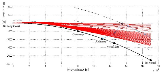
The normal optical horizon distances from the Trislander at the start and end of the observation were 69nmi and 48nmi respectively, so that it was necessary also to invoke mirage refraction in order to connect the light ray paths from the Breton coast to the observers. In this we were adapting a "mock-mirage" theory suggested to us by atmospheric physicist Les Cowley, an unusual optical geometry in which ducted light rays (rays refracted with a radius of curvature close to the 33"/km curvature of the earth and effectively trapped inside the refracting layer) escape the duct at an upward angle towards observers situated above the top of the duct n2Cowley, L., CHANNEL ISLANDS SIGHTINGS: An Investigation into Possible Role of Atmospheric Optical Phenomena, 2007. This excellent 9-page report was kindly prepared for us by Dr Cowley at an early stage in our investigation, and helped greatly to focus the direction of our efforts..
We did find evidence (Section 5) that there was a low-level advection inversion with an average gradient of ~10°C/100m over the coastal waters off the N of Brittany - close to a trapping gradient - diminishing by a factor 10 at some point south of the Channel Islands area. It seemed possible to us that light rays ducted from the Breton shore might leak from the weakening duct at some point south of Guernsey and present an over-the-horizon "mock mirage" image of a bright sea bay to observers at 4000ft many miles away. (In principle a duct might even trap sun glitter reflections from as far away as the Bay of Biscay, but raypaths from the Bay of Biscay cannot couple into this Breton coastal duct which extends only to about 200m altitude, significantly lower than the Breton hills in the line of sight.)
A, north Guernsey; B, south Guernsey; C & D, coastal waters off Brittany. (Data from Lucien Wald, Helioclim/SODA, Centre Energetique et Procedes Ecole des Mines de Paris, CNRS)

A computer raytrace simulation was produced (Fig.24) assuming a 65 km duct (~10°C/100m, producing a -170N/km refractive index gradient) extending from the northern coast of Brittany toward the Channel Islands (highly weakened at this point to ~1°C/100 m), with a 10 km transition toward a standard atmosphere. The Trislander's approximate descent slope from the 4000ft to 2000ft flight levels is indicated. Evidently it might be possible with a small adjustment of the parameters to arrange things such that the aircraft passes out of the bottom of the pencil of refracted rays at about 2000ft, resulting in disappearance of the mirage.
A candidate bay was located at Plougasnou, 48.7N, 3.8W (Fig.25). This bay, a popular surfing area, lies close to the line of sight to the UAPs n3 It also contains a patch of off-shore rocks which, by interrupting wave trains coming from the NNE and/or masking the specular reflection direction at a low elevation angle, might conceivably also explain a strange "graphite grey band". Realistically, waves would be refracted around it rather than neatly blocked as idealised in Fig.25, but Capt Bowyer's report that the edges of the band(s) had an odd "glittering" quality is certainly suggestive of sunlight on the sea. Or maybe these bands were shadows cast by a/c contrails or dense cloud streaks? The shadow of a high contrail can sometimes be seen cast on a lower cloud deck. Viewed from below, the light scattered through the cloud brightens it except in the shadow, which can appear as a quite well-defined dark line. There is evidence of high contrails S of Guernsey on the 1328 MODIS satellite photo (Section 3) but these are above high cloud and moreover appear to have dissipated by 1400. It seems scarcely realistic that cloud shadows could be sharp enough (penumbral diffraction) to be prominent against a glitter pattern.. We obtained and graphed (p.69) satellite measurements of solar irradiance on coastal water at two coordinates in this area n4Thanks to Lucien Wald, Helioclim/SODA, Centre Energetique et Procedes Ecole des Mines de Paris, CNRS.. In both cases the irradiance was (within uncertainty) the same as the clear-sky expectation of approx 730W/m2.
We found that this theory does encounter some difficulties. The brilliance of a possible sunglitter pattern in this area would be sensitive to the wave slope (~20° would be optimum for specular reflection), wave orientation and sun position. Since the sun azimuth is within a few degrees of the line of sight the preferred swell direction for favourable specular reflection would be from the NNE, which does occur in certain weather conditions. But it is not the prevailing wave direction in the Channel. The prevailing direction is from the W. Initial findings about the off-shore wave direction and wave slope on 23 April 2007 were not encouraging.

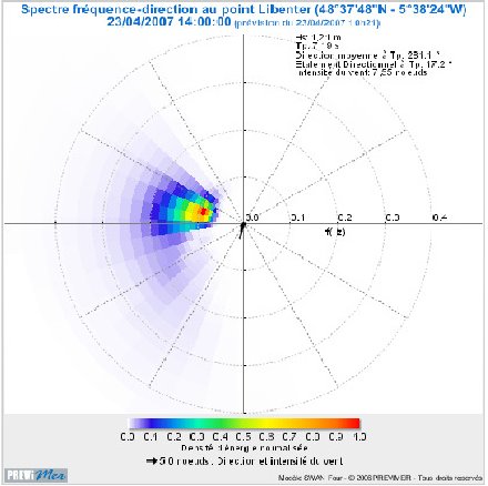
The Libenter wave buoy located at 48° 37' 48"N, 5° 38' 24"W off the NW tip of Brittany showed the wave direction to
be 281° (somewhat north of west) at 1400Z, varying negligibly. A significant wave height of only 1.21m with a period
of 7.19sec indicates a slight sea state with a very shallow wave slope of only a degree or two. At 1400Z the Channel
Light Vessel at 49° 54' 0" N 2° 54' 0" W (~ 100 km west of ORTAC) measured wave heights of only 0.80m with a period of
8.0sec, indicating wave slopes as small as 0.6°
n5
https://www.ndbc.noaa.gov/station_page.php?station=62103. In other words the wave fronts in the open sea
were orthogonal to the required direction for efficient specular reflection (Fig. 26) Moreover the sea was very calm,
with wave slopes at least an order of magnitude smaller than the 20°optimum for specular reflection n6The wave amplitude in the S Channel Islands area itself, measured by wave-rider buoy 6 miles off Corbiere, SW
of Jersey, was smaller still (email 23.07.07 Jersey Planning & Environment Dept , Fisheries & Marine Resources):
n7| Time (GMT) | Sig Wave (m) | Period (s) | Max Wave (m) |
| 13:00 | 0.67 | 6.3 | 1.00 |
| 14:00 | 0.70 | 6.7 | 1.28 |
| 15:00 | 0.69 | 6.9 | 1.34 |
n8All these figures confirm the Channel Islands noon shipping forecast (Appendix C, Table 3) of a "smooth or slight"
sea state with "insignificant" swell. The Corbiere buoy does not record wave direction. .
Shoaling waves encountering shallower water will tend to be refracted towards the shoreline, rotating the wave fronts clockwise in this case; but we had little expectation that this rotation at Plougasnou could reach the ~100° suggested in Fig.24, except perhaps very close in-shore. In an area several kilometers off-shore, where the depth will be large compared to the negligible swell amplitude, there could be no refraction. Swell crests would remain near parallel to the line of sight, not perpendicular to it as required.
On the other hand waves are composed of many different frequencies with wavelengths from tens of metres to millimetres, and we learned n9C. Cox & W. Munk, Slopes of the Sea Surface Deduced from Sun Glitter, Bulletin of the Scripps Institute of Oceanography, Vol. 6., #9, 1956, pp 401-88; various emails to J-F Baure and Martin Shough from Andrew T Young (atmospheric scientist, San Diego State U) 28.08.07 - 01.09.07. n10N. Ebuchi and S. Kizu, Probability distribution of surface wave slope derived using Sun glitter images from geostationary meteorological satellite and surface vector winds from scatterometers, J. Oceanography 58, 477 (2002); L. C. Bobb, G. Ferguson, and M. Rankin, Capillary wave measurements, Applied Optics 18, 1167 (1979) that in any case the brilliant point reflections making up a specular sun glitter pattern come mostly from the tiny capillary waves on the scale of millimetres. We found that some 20° slopes would be produced even by light winds of only 3-4m/sec (~7 knots) recorded in the Channel Islands area. So despite the unfavourable orientation of the underlying gravity waves, if such winds were blowing across the wave crests from the correct SSW direction they might encourage more favourably oriented near-transverse friction capillaries. Surface winds in the area generally were indeed recorded (Section 5) as roughly SSW.
But the rms wavelet slope (linearly proportional to wind speed) would be only ~ 4-5°. Could the tail end of the distribution contain enough 20° slopes for efficient sun glitter? We sought expert advice from Bertrand Chapron of the French oceanographic agency IFREMER, who was pessimistic about this theory: The favourable capillary slopes at favourable orientations would be far too few in these conditions and the brilliant point reflections too scattered, leading in his opinion to a low aggregate intensity of reflected light. In short, bright sun glitter from these waters would be unlikely. He advised us to pursue other avenues n11Emails to J-F.Baure from Bertrand Chapron, IFREMER, Brest, 10.09.07 & 11.09.07.
An ALADIN numerical simulation of wind vectors over coastal water was produced for us by Meteo-France (see Section 5). The 4-hour animation (Fig.27) shows the surface wind rotating clockwise and weakening, until by 1300Z it is a 1 - 2 knot breeze blowing from the NW, aligned with the swell direction and across the LOS. The likelihood of significant coastal sun-glitter in these conditions seemed negligible. However records of coastal winds at Ploumanach n12 https://climatheque.meteo.fr/okapi/accueil/okapiWeb/index.jsp indicate a continuing sea-breeze development which may have produced a N-NE surface breeze by the sighting time, and thus more favourable transverse capillary crests, but speeds of ~1-2m/sec (gust max. 3m/sec) remain low (given an adverse gravity wave vector) for the desired wave slope.
Even a poor slope distribution might be acceptable if we are prepared to consider speculative processes. Raman brightening is one possibility, a rare interference phenomenon due to raycrossing that amplifies the flux density in a narrow layer at the top of an optical duct. Although the Raman effect is very sensitive to tiny changes in the viewing angle relative to the top of the duct and it seems unlikely that it could persist through many minutes of flight with a change of altitude of <2000ft, conceivably there could be other related rare focusing effects in the duct that might concentrate the luminous flux in a narrow band. But even then, problems remain.
In standard theory, the critical viewing angle for all atmospheric optical refraction effects, whether true mirage or not, is small - less critical than the angle-sensitivity of microscopic interference effects like Raman brightening, but already a serious constraint. Mirages are usually seen through a narrow height range of a few meters or at most a few tens of meters for a very strong inversion. In this case the need to maintain a small angle for many minutes during flight for tens of miles and through an altitude change of about 2000 ft puts a strain on any optical theory n13Email to J-F Baure from Andrew T Young, San Diego U., 28.08.07, and this is only increased by the requirement that it rather accurately simulate aspects of the sighting geometry of a physical object in local space:
Between 1406 and 1418 the angular sizes of both UAPs grew larger. The estimated angular width of UAP#1 increased from ~0.5° to ~1.25°, corresponding to an enlargement factor of between 2.14 and 3.0 between the initial and final sightings. We have shown (Section 3) that the mean of these values (2.6) is very close to the ratio (2.8) of the two ranges from the aircraft to the triangulated position of UAP#1 near Alderney at these times. But the expected enlargement ratio of features near the Breton coast, about 6 times as distant, would be only about 1.3.
The motions of the images are also very difficult for an optical theory. In Section 3 we saw that the reconstructed sighting geometry shows a 10° westward rotation of the LOS to UAP#1 not accounted for by rotation of the aircraft's frame of reference during the turn towards Alderney. If real this would rule out a simple mirage theory. This is not a strong piece of primary evidence inasmuch as it could be that a quantitative witness error in estimating relative bearings is causing an error in the reconstruction; but the reconstruction (Fig.7) locks in, in a self-consistent way, other angular motions that are strong, non-negotiable features.
The observed azimuth separation of two identical images - whether these be images of source and mirage, or images of a common unseen source miraged twice - has no conventional atmospheric refractive mechanism. And critically, a steady horizontal motion of these two images relative to one another through an arc of several degrees is even more difficult to explain. Lateral refraction of light rays of more than a few seconds of arc (order of 10-3 smaller than reported) is regarded as physically impossible n14In the free atmosphere. So-called "lateral mirage" occurring next to a sun-heated wall or similar is a special case.. This is a displacement smaller than the smallest angular distance resolvable by the human eye n15The two distinct objects were "very plain to see . . . without binoculars". They were also observed with binoculars, but maximum lateral mirage displacement would still be an order of magnitude smaller than the angle resolvable with 10-power optics, and by contrast the 10x magnified image separation reported would be equivalent to a nakedeye angle of about 20°. . Moreover, any tiny lateral refractions that might occur due to horizontal thermal fluctuations (not stable gradients) cannot explain lateral displacements, howsoever small, persisting for many minutes.
And finally of course this theory is of no help in explaining the observation of the yellow/beige oval by the Jetstream pilot, at a near-reciprocal bearing.
Plausibility (0-5): 2